Block 1, Article 1
© 2026 Steve Sagnotti.
The American continent was not a wilderness waiting to be discovered. It was a foundation waiting to be spent.
Four hundred million beavers had spent thousands of years engineering the wetland systems of North America into one of the most productive landscapes on earth. Beavers build dams. Dams slow water. Slow water spreads across floodplains, settles into the ground, and stays. The dark topsoil of the Corn Belt — the soil that still feeds a significant fraction of the world — is largely what all that slowed water produced over millennia. The commons was not only the thing itself. It was the system that made everything else possible.
What was here
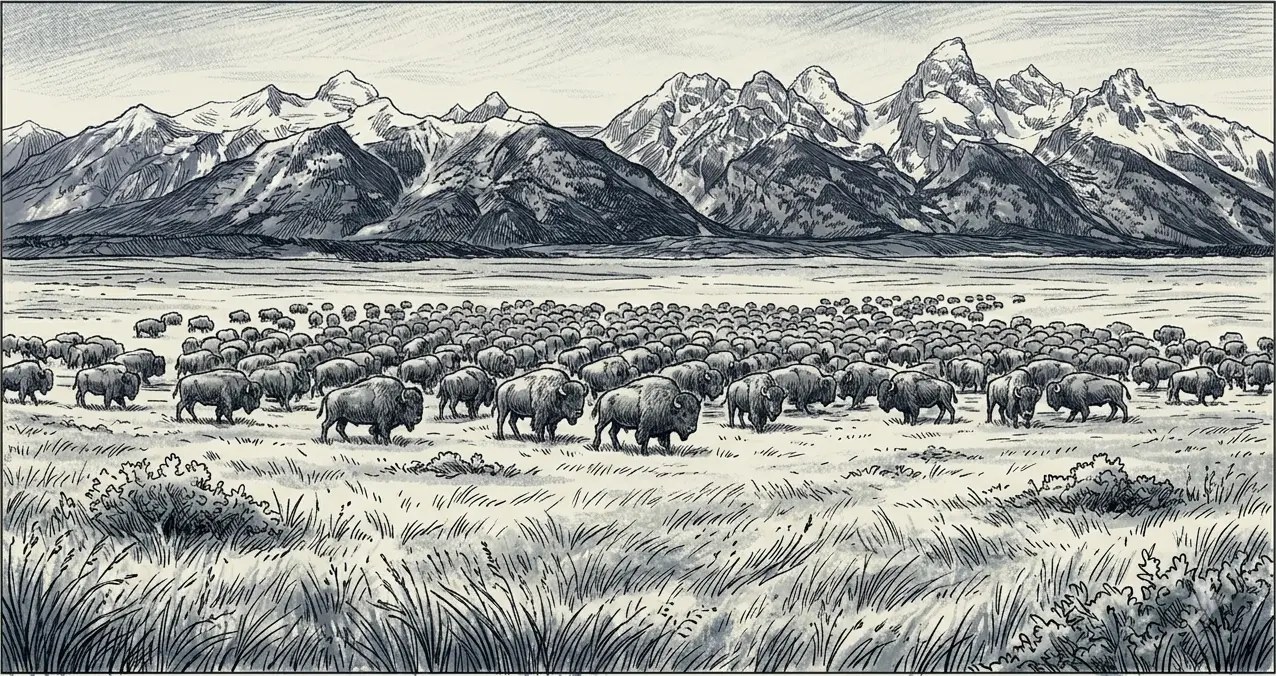
The bison numbered between 30 and 60 million on the Great Plains — a biomass so large it shaped the ecology of an entire continent. The herds cropped the grasses, their hooves aerated the soil, their movement across the plains drove the nutrient cycling that kept the grasslands productive. The western grasslands supported the grazers that supported the predators that supported the entire plains ecology — a self-regulating system running on solar energy and rain that had operated for thousands of years before a European eye fell on it.
The Atlantic fisheries were so thick with cod that early explorers reported they could be scooped from the water in baskets. John Cabot’s crew in 1497 described lowering weighted baskets over the side of the ship and pulling them up full. The Grand Banks off Newfoundland held what was, for three centuries, the most productive fishery on earth. Closer to shore, the oyster reefs of Chesapeake Bay filtered the entire volume of the Bay every three to four days. The river systems of the Pacific coast held salmon runs so dense that Lewis and Clark, crossing the Rockies in 1805, described the Columbia as leaping with fish — a run so large it could be heard before it could be seen.
Before European settlement, a billion acres of forest covered what is now the United States. The eastern seaboard was dense hardwood — chestnut, oak, maple — a canopy so continuous that legend held a squirrel could travel from the Atlantic to the Mississippi without touching the ground. The Great Lakes held white pine at a scale the logging industry arriving in the 1840s would call inexhaustible. The Pacific Northwest held Douglas fir and Sitka spruce at dimensions the eastern loggers had never encountered. The southern longleaf pine ecosystem ran from Virginia to Texas — 90 million acres of a single forest type, an ecological community that had shaped the culture, the economy, and the hydrology of the American South for millennia.
Below the surface of all of it, a layer that made the agriculture possible. The A-horizon — the dark, carbon-rich topsoil — took thousands of years to form from the chemistry of decomposition, root systems, and the slow biological work of the grassland and forest ecosystems above it. When the Corn Belt was broken for agriculture in the mid-19th century, it was spending accumulated biological capital, not generating new wealth. Beneath eight Great Plains states, the Ogallala Aquifer held fossil water accumulated from Pleistocene glacial melt over six million years — the largest groundwater deposit in North America, the underground reservoir that would eventually make the semi-arid plains bloom.
The forests. The fisheries. The grasslands. The topsoil. The aquifer. These were not resources waiting to be created. They were inheritance — the accumulated output of geological time, biological process, and ecological systems operating at scales the human economy had not yet learned to measure or to miss.
The scale of the before
640 million acres of public land. A billion acres of forest. Six million years of groundwater. Salmon runs so dense they could be heard. Cod dense enough to fill a basket. Bison in numbers large enough to darken the horizon for days as a herd passed.
This is not a romantic inventory. These are the documented figures — the baseline against which everything the mechanism blocks document is measured. Block 10 closes the accounting. The distance between the before described in this article and the after documented there is the series argument made visible.
The abundance this article inventories had one property that made everything else possible and everything else dangerous: it looked inexhaustible. The continent was large enough, the resources dense enough, the regeneration rates — in the centuries before the technology arrived to outrun them — fast enough that the assumption of endless supply was not obviously wrong. The cod had been there since before anyone could remember. The bison had numbered in the tens of millions across recorded history. The aquifer had never run dry.
The assumption held until the technology arrived that could take faster than the commons could replenish. Then it didn’t hold at all. The Great Lakes white pine — inexhaustible in 1840 — was effectively gone by 1900. The Atlantic cod sustained a civilization for four centuries and collapsed to one percent of its historic biomass in a single generation once industrial trawling reached it. The Ogallala is being drawn down at rates that dwarf its natural recharge, on a timeline measured in decades in the most stressed regions.
The abundance was real. The assumption of inexhaustibility was not. What changed between the two was the technology — and what the technology revealed was that the commons had always had a ceiling. The country just hadn’t found it yet.
Sources
1. Pre-contact beaver population 400 million. Naiman, R.J., Johnston, C.A., & Kelley, J.C. (1988). “Alteration of North American streams by beaver.” BioScience 38(11): 753–762. WorldCat: https://search.worldcat.org/title/1231932251 — Secondary: Beavers: Wetlands & Wildlife: https://www.beaversww.org/2019/05/08/wetland-engineer/
2. Bison 30–60 million. Dan Flores, American Serengeti (2016). University Press of Kansas.
3. Cabot 1497 / cod in baskets. Mark Kurlansky, Cod (1997). Walker & Company. WorldCat: https://search.worldcat.org/title/1368216880
4. Grand Banks productivity. NOAA Fisheries. https://www.fisheries.noaa.gov/feature-story/history-and-science-grand-banks
5. Chesapeake Bay oyster filtration 3–4 days. Chesapeake Bay Foundation. https://www.cbf.org/about-the-bay/more-than-a-magazine/chesapeake-quarterly/a-keystone-species-recovering-oysters-and-the-chesapeake-bay/
6. Lewis and Clark Columbia River salmon. Journals of Lewis and Clark, 1805. Library of Congress. https://www.loc.gov/collections/lewis-and-clark-journals/
7. Forest cover 1 billion acres pre-settlement. USGS / Newsweek, March 2025. https://www.newsweek.com/map-reveals-how-americas-forests-have-changed-over-time-2052339
8. Southern longleaf pine 90 million acres. Longleaf Alliance. https://www.longleafalliance.org/what-is-longleaf
9. A-horizon / topsoil formation. USDA NRCS. https://www.nrcs.usda.gov/conservation-basics/natural-resource-concerns/soils/soil-health
10. Ogallala Aquifer — six million years / fossil water. USGS Circular 1182. https://pubs.usgs.gov/circ/1182/
11. 640 million federal acres. BLM. https://www.blm.gov/about/what-we-do/desert
12. Great Lakes white pine collapse 1840–1900. USFS history. https://www.fs.usda.gov/inside-fs/delivering-mission/excel/history-forests-national-forests
13. Atlantic cod collapse to 1% of historic biomass. DFO Canada. https://www.dfo-mpo.gc.ca/fisheries-peches/ifmp-gpmp/groundfish-poissons-demersaux/cod-morue2019-eng.htm
14. Ogallala depletion rates vs. recharge. USGS groundwater monitoring. https://www.usgs.gov/mission-areas/water-resources/science/groundwater-depletion
Block 1, Article 1. © 2026 Steve Sagnotti.
Leave a Reply