Block 3, Article 4 — The Input Was Corrupted First
© 2026 Steve Sagnotti.
What do a missing census count, a closed newspaper, and a mining claim have in common?
The previous three articles documented what happens to your representation after the map is drawn. This one shows what happened before.
The courts that might have protected specific communities from gerrymandering are now closed — Rucho shut the partisan door, Callais shut the racial one. The communities those remedies were designed to protect are the same communities this article is about. That is not a coincidence. It is a sequence.
The count that shapes everything
Every ten years, the federal government counts the population of the United States. The count does two things. It determines how many congressional seats each state receives. And it determines how approximately $2.8 trillion in federal funding — for schools, hospitals, roads, housing assistance, emergency services — gets allocated across communities over the following decade. On both measures, the count is the input. Get the count wrong and everything downstream is wrong.
The count is not accurate.
The Census Bureau conducts its own independent post-enumeration surveys after each decennial count — separate samples used to measure how accurately the census counted specific populations. The results are consistent across decades. Black Americans, Latino Americans, Native Americans, renters, young men, and recent immigrants are systematically undercounted. White non-Hispanic homeowners are overcounted — recorded in greater numbers than actually exist in that category. The net effect is that seats and federal dollars followed a map of America that wasn’t there.
The 2020 census undercounted the Hispanic population by 4.99 percent. It undercounted the Black population by 3.30 percent. It overcounted the white non-Hispanic population by 1.64 percent.
These are not rounding errors. Applied across the populations of large states, they shift congressional seats. They alter district lines. They redirect federal funding away from the communities most undercounted — the same communities that will then be gerrymandered, served by fewer local newspapers, and located nearest to extraction sites.
The federal government measures its own counting errors. It publishes them.
The intent was documented
For years, methodology took the blame for the differential undercount — the inherent difficulty of counting a large, mobile, diverse population once per decade with a physical form. Then Thomas Hofeller died.
Hofeller was the Republican Party’s premier redistricting strategist for three decades. After his death in 2018, his daughter found hard drives containing working files that documented, in his own words, the actual purpose of the 2020 citizenship question. Adding a citizenship question to the census, Hofeller’s files showed, would allow drawing congressional districts based on citizen population rather than total population — concentrating representation in whiter, more rural, more Republican areas. The stated rationale offered to the courts — Voting Rights Act enforcement — was, the files showed, pretextual. The argument had been constructed after the strategic objective was identified.
The Trump administration had framed the citizenship question as a civil rights measure. Hofeller’s own files documented what the frame excluded: the intent to engineer the input before the map was drawn.
The Supreme Court blocked the question in Department of Commerce v. New York (2019) — but on procedural grounds only. It found the rationale pretextual. It did not rule the underlying intent unconstitutional. The intent is still available to anyone who controls the Department of Commerce. Closing that window permanently requires either continuous census methodology — which removes the decennial manipulation opportunity entirely — or congressional action to mandate it, from the chamber the corrupted count helped produce.
The mechanism is not mysterious
The overcounting is not random. People with two homes — a primary residence and a vacation property — get counted at both. A college student gets counted at their campus address and again when their parents list them at the family home. Duplicate forms, submitted by households uncertain whether the first one registered, slip through imperfect matching algorithms.
The fix is not technically difficult. Cross-referencing census responses against Social Security records, IRS filings, Medicare enrollment, and USPS address databases would catch most duplicates before publication. The Census Bureau already uses administrative records partially. It has not extended that matching to full pre-publication deduplication.
Privacy constraints and limits on cross-agency data sharing are the official explanation. The more complete answer is visible in a different program. The federal government automatically registers every 18-year-old male for the Selective Service within months of his birthday — cross-referencing Social Security records, school enrollment data, and other administrative sources in real time. The infrastructure for accurate population tracking from administrative records exists. It operates reliably for conscription. It has not been applied to representation.
The government that can find every young man for the draft cannot deduplicate a census form. The asymmetry is not technological. It is a choice about which kind of finding empowers whom.
The Census Bureau is a federal agency, subject to the same regulatory capture Block 8 documents in the agencies that set royalty rates and grazing fees. The money pipeline that protects below-market extraction rates has no obvious reason to fund a bureau adopting counting methods that would shift seats and federal dollars away from the districts that pipeline already controls.
The same map
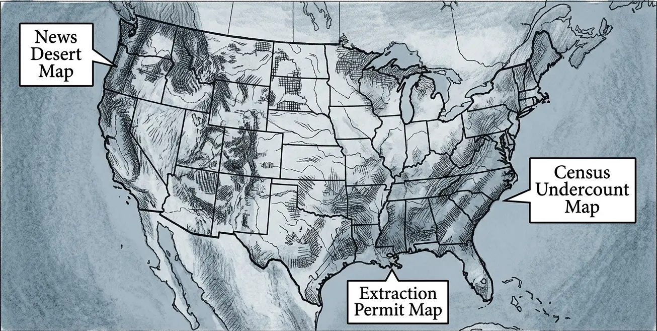
Here is what the data shows when you overlay three separate federal datasets.
The communities most systematically undercounted in the census are concentrated in rural tribal lands, dense urban cores, and rural areas with high concentrations of Latino agricultural workers and Black residents in the South. The communities that have lost their local newspapers — the news deserts documented by the Northwestern Medill Local News Initiative — overlap those same geographies. The communities bearing the highest costs from below-market federal mineral extraction — the royalty rates, the aquifer drawdowns, the grazing fee subsidies — are concentrated in the same areas.
Draw the undercount map. Draw the news desert map. Draw the extraction zone map. They are not three maps. They are one map, drawn three times by three different federal data collection systems that have never been placed next to each other in a single public accounting.
The census undercount dilutes their representation before a single district line is drawn. The gerrymander then dilutes it further. The news desert ensures their representative faces no local accountability. The extraction zone ensures that what remains of their commons is priced at rates set by the committee chairs those diluted districts could not unseat. The undercount that did this was not accidental — the communities bearing the extraction costs are the same communities the citizenship question was designed to dilute further. The count and the map were aimed at the same target.
This is not four separate problems. It is one problem with four expressions.
The communities bearing the cost of the commons extraction documented in Block 10 are the communities whose political weight was reduced — systematically, measurably, upstream of every other mechanism this series documents — before anyone picked up a mapping program.
Block 10 carries the full accounting of what that cost them. The map that couldn’t be challenged in court was drawn on a canvas already tilted by a count that never got them right.
The district produces a legislator with a specific accountability structure. The next block shows what that structure looks like from the inside.
The Rigged Map — The Record Is Public
| 2020 Post-Enumeration Survey — how accurately your community was counted | https://www.census.gov/library/publications/2022/dec/p94-171.html |
| Your district’s partisan fairness grade and efficiency gap score | https://gerrymander.princeton.edu |
| Federal oil, gas, and mineral lease activity in your state — active vs. idle | https://www.blm.gov/programs/energy-and-minerals/oil-and-gas/leasing |
| Whether your state uses an independent redistricting commission | https://redistricting.lls.edu |
| Your representative’s donors and committee assignments | https://www.opensecrets.org |
A representative operating in a broader frame could tell you how their district was drawn, by whom, and under what rules. They could tell you whether their committee assignments align with their district’s interests or their donors’. They could tell you whether they support restoring compactness requirements, an independent redistricting commission, and continuous census methodology. Ask.
Sources
1. 2020 Post-Enumeration Survey. U.S. Census Bureau, March 2022. https://www.census.gov/library/publications/2022/dec/p94-171.html
2. Census Bureau press release, March 10, 2022. https://www.census.gov/newsroom/press-releases/2022/2020-census-estimates-of-undercount-and-overcount.html
3. Federal funding allocated by census — $2.8 trillion figure.
4. Hofeller files — citizenship question intent documented. New York Times, May 30, 2019 (paywall). “Deceased G.O.P. Strategist’s Hard Drives Reveal New Details on the Census Citizenship Question.”
5. Department of Commerce v. New York, 588 U.S. 752 (2019). https://supreme.justia.com/cases/federal/us/588/752/
6. Northwestern Medill Local News Initiative. https://localnewsinitiative.northwestern.edu
7. Selective Service administrative infrastructure. 50 U.S.C. § 3802. https://uscode.house.gov/view.xhtml?req=granuleid:USC-prelim-title50-section3802&num=0&edition=prelim
8. News desert / undercount overlap. Brennan Center for Justice. https://www.brennancenter.org
9. Cross-agency data matching / administrative record census methodology. U.S. Census Bureau. https://www.census.gov/topics/research/linkage/administrative-records.html
Block 3, Article 4. © 2026 Steve Sagnotti.
Leave a Reply